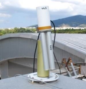
CIMEL sunphotometer
| PI | Vassilis Amiridis |
| Participant | National Observatory of Athens |
Near-real time data are available at AERONET's website.
The CIMEL sunphotometer of FORTH-CRETE or ATHENS-NOA AERONET station will be employed and registered in AERONET under the new position at Finokalia.
NASA’s AERONET (Holben et al., 1998 -http://aeronet.gsfc.nasa.gov) is a global sunphotometric network mainly distributed in North America and Europe. The network employs the Cimel CE318 sunphotometer as the standard instrument. More than 250 units take part in AERONET.
Retrieved aerosol products are column properties for the aerosol optical depth (AOD) at several wavelengths of the solar spectrum (380, 440, 500, 675, 870, 1020 and 1640 nm) and the Ångström exponent at 440/870 nm, the size-distribution and the complex refractive index and single scattering albedo (SSA) at 440, 675, 870 and 1020 nm. The products for size, refractive index and SSA are derived from the sky-radiances at 440, 675, 870 and 1020 nm.
Products
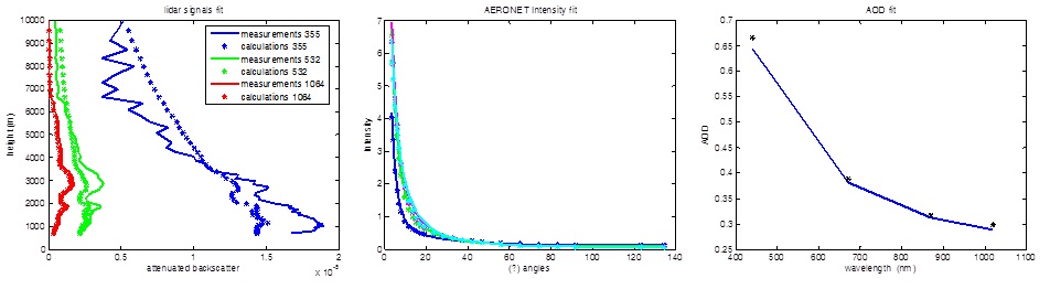
During the CHARADMexp campaign the AERONET measurements will be combined with lidar measurements for retrieving the optical and microphysical aerosol property profiles with GARRLiC algorithm (Lopatin et al. 2013).
The GARRLiC algorithm is initialized in the frame of ACTRIS to utilize the capabilities of combined AERONET/EARLINET stations in Europe. The algorithm retrieves the profiles of aerosol microphysical properties using the sunphotometer measurements of the sky radiance and optical thickness and the multi-wavelength elastic lidar measurements.
In particular, GARRLiC retrieves the size distribution, the spherical particles fraction and the spectral refractive index, considering them constant along the atmospheric column, separately for fine and coarse particles, as well as the concentration profiles of fine and coarse particles.
A new product provided by GARRLiC is the single scattering albedo profile, which is of great importance for radiative simulations and climate studies.

Recent measurements
| Measurement | Start time | Duration |
|---|---|---|
| CIMEL | July 16, 2014, midnight | 1 day |
| CIMEL | July 15, 2014, midnight | 1 day |
| CIMEL | July 14, 2014, midnight | 1 day |
| CIMEL | July 13, 2014, midnight | 1 day |
| CIMEL | July 12, 2014, midnight | 1 day |
| CIMEL | July 11, 2014, midnight | 1 day |
| CIMEL | July 10, 2014, midnight | 1 day |
| CIMEL | July 9, 2014, midnight | 1 day |
| CIMEL | July 8, 2014, midnight | 1 day |
| CIMEL | July 7, 2014, midnight | 1 day |
| CIMEL | July 6, 2014, midnight | 1 day |
| CIMEL | July 4, 2014, midnight | 1 day |
| CIMEL | July 3, 2014, midnight | 1 day |
| CIMEL | July 2, 2014, midnight | 1 day |
| CIMEL | July 1, 2014, midnight | 1 day |
| CIMEL | June 29, 2014, midnight | 1 day |
| CIMEL | June 28, 2014, midnight | 1 day |
| CIMEL | June 26, 2014, midnight | 1 day |
| CIMEL | June 25, 2014, midnight | 1 day |
| CIMEL | June 24, 2014, midnight | 1 day |
| CIMEL | June 23, 2014, midnight | 1 day |
| CIMEL | June 22, 2014, midnight | 1 day |
| CIMEL | June 21, 2014, midnight | 1 day |
| CIMEL | June 20, 2014, midnight | 1 day |
| CIMEL | June 19, 2014, midnight | 1 day |
| CIMEL | June 18, 2014, midnight | 1 day |
| CIMEL | June 17, 2014, midnight | 1 day |
| CIMEL | June 16, 2014, midnight | 1 day |
Recent activity
News
- ITaRS participation in CHARADMExp (Jul 10th)
- UAV measurements (video) (Jul 1st)
- Cyprus Institute UAVs are heading to Sitia's airport (Jun 26th)
- Saharan dust is approaching (Jun 24th)
- Getting prepared for UAV flights over Crete (Jun 23rd)
Uploaded data
- HALO realtime (Sep 9th)
- FLEXPART (Jul 31st)
- WRF WIND (Jul 31st)
- WRF WIND (Jul 31st)
- WRF WIND (Jul 31st)
CHARADMexp campaign is funded by the European Space Agency.
CHARADMexp is supported by the BEYOND Centre of Excellence, in the frame of the satellite cal/val activities performed by the Centre. LIVAS climatology as well as the smoke dispersion and dust services provided by BEYOND will be validated through the CHARADMexp campaign.
ACTRIS provides support to CHARADMexp participants by offering access to the Finokalia research facilities through the Transnational Access activity of the Network.